Years later, while in college I discovered that the ‘Clouds’ command of Photoshop combined with increasing the contrast gave similar images to that old memory of an imaginary coastline. I played around with this for a long time, trying out different experiments, thinking about the places these maps represented and trying to find a way to zoom in on the coastline in a meaningful way. But I never found that functionality.
Then I learned how to program.
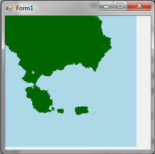
It took me a long time to get back to the idea though. It always seemed like a lot of work for an unclear gain. It wasn’t until my programming confidence was high enough that I decided to do it. It still took some doing as I learnt the difference between square noise and diamond square noise. But eventually I wrote this program:
DiamondSquareTest.exe
(Left click to zoom in on a point, right click to zoom out.)
However, I didn’t have anything to do with it other than spend a few hours exploring random coastlines. Which I did. But I feel like there should be some way to either make a game out of this or to make it a useful tool for sit down role players. I’m aware of a few bugs in the program, and I can think of some obvious improvements – but without a clear end point for why someone would want a map that they can endlessly zoom into, I’ve never felt like fixing it.
Which is why I’m posting this here. If anyone can suggest any uses for this, I would be highly appreciative.
4 comments:
I always liked various games that allow you to pick up & move various elements. The endless zoom function would be good for that.
It reminds me a little of Google Earth.
Possibly a program where you get to pick up & drop bits of coastline or geography for designing countries or lands? That would be a more back-end application or design system than game-applicable.
That's off the top of my head. I'll be giving it more thought, but V-con's this weekend, so don't expect further response anytime soon (grins)
I think at this point I'm leaning towards tool for pencil and paper RPGs... so moving coastlines around totally works.
However, I've never really used those sorts of tools for an actual game, so I'm not sure what I need to include in order for it to be useful to people.
Around a year ago I found this program for pen and paper RPG map-making, Steve and my friend Will have both played with it a bit.
http://autorealm.sourceforge.net/index.php
They're open-source, so you can see what they used?
I guess you know my answer to that Kalev. ;o) I've always loved exploring new worlds, just apply the same ideas to everything, and repeat...
Post a Comment